
Orange Weather Alert for Most of Iceland
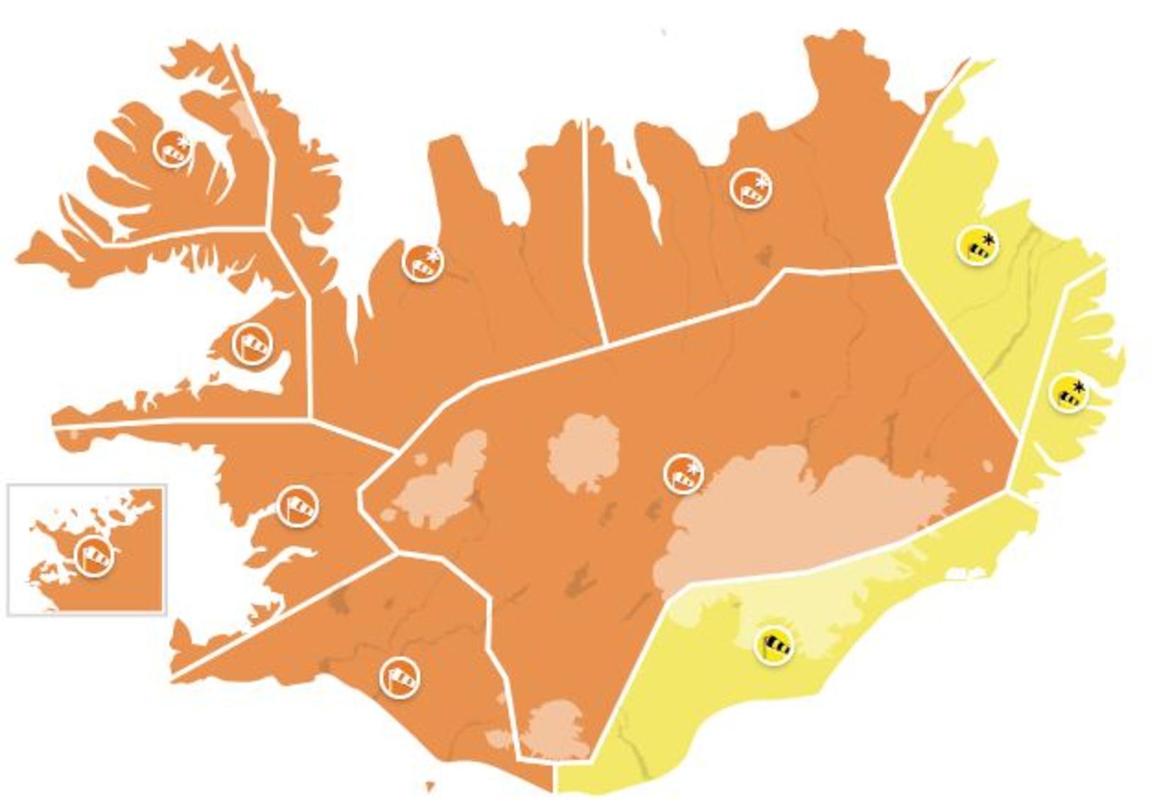
The warning will be in effect for most of the country tomorrow. Map/Icelandic Met Office
The Icelandic Met Office has issued an orange weather alert for tomorrow for most parts of Iceland. Please follow the weather forecast closely, since severe weather is expected.
The weather will likely affect transportation in North and West Iceland, in addition to interrupting domestic as well as international flights. Travel in the affected areas is not advised, and residents are asked to securely fasten all loose items outdoors. Building contractors are reminded to take construction material and equipment to shelter, as are companies with operations by harbors.
Residents in North and West Iceland should prepare for potential power shortages, likely to last until the storm has passed.
The warnings are as follows:
Reykjavík and vicinity
An orange warning is in effect from 4 pm tomorrow until 7 am Wednesday. A northerly severe gale or storm is expected, with wind speeds of 20-28 m/sec. Transportation will likely be affected. Expect traffic delays. Damage due to flying debris likely, and construction workers are encouraged to secure construction sites. Higher sea levels are anticipated due to a storm surge, with the possibility of small boats being damaged or detached from the dock. People are advised to secure their surroundings, fasten loose items and show caution. Travel is not advised while the weather warning is in effect.
South Iceland
An orange warning is in effect from 3 pm tomorrow until 10 am Wednesday. North and north-westerly strong gale or storm of 20-28 m/sec is expected, first in the western part. The closure of some main roads can be expected. Risk of damage due to flying debris can be expected, and people are advised to secure their surroundings, fasten loose items and show caution. Travel is not advised while the weather warning is in effect. Wind will decrease early Wednesday, but remain at 23-33 m/sec near Eyjafjöll mountains until Wednesday evening.
Faxaflói bay area
An orange warning is in effect from 1 pm tomorrow until 10 am Wednesday. A northerly storm of 20-28 m/sec will develop. Extensive transportation disturbance is likely, including the closure of some key routes. Risk of damage due to flying debris can be expected, and people are advised to secure their surroundings, fasten loose items, show caution and monitor the weather forecast. Travel is not advised while the weather warning is in effect.
Breiðafjörður fjord
An orange warning is in effect from noon tomorrow until 8 am Wednesday. A northeasterly and then northerly storm of 23-30 m/sec is expected. Snow and blowing snow likely, with decreasing visibility. The weather is likely to cause transportation disturbances. Travel is not advised while the weather warning is in effect. People are advised to secure their neighborhood and show caution.
The West Fjords
An orange warning is in effect from 7 am tomorrow until 9 am Wednesday. Northeasterly and then northerly storm of 23-30 m/sec is forecast, and moderate or severe snow, or blowing snow, can also be expected with limited or poor visibility and deteriorating road conditions. The weather is likely to cause transportation disturbances and traveling is not advised while the weather warning is in effect. People are advised to show caution and monitor the weather forecasts.
Northwest Iceland
An orange warning is in effect from 7 am tomorrow until 2 pm Wednesday. A northeasterly and then northerly storm of 23-33 m/sec is expected, in addition to moderate or severe snow, or blowing snow, with very poor visibility and deteriorating road conditions. The weather is likely to cause transportation disturbances and travel is not advised while the weather warning is in effect. Higher sea levels, as well as wave height up to 10 m, are anticipated due to a storm surge, with the possibility of small boats being damaged or detached from the dock. People are advised to show caution and monitor weather forecasts.
Northeast Iceland
A yellow warning is in effect from 3 to 8 am tomorrow, followed by an orange warning from 8 am tomorrow until 9 pm Wednesday. A northeasterly and later northerly storm of 23-30 m/sec is expected, as well as moderate or severe blowing snow, with poor visibility and deteriorating road conditions, mainly in the Eyjafjörður area and on mountain roads. Much lighter wind is forecast in the easternmost part of the area through Tuesday evening. The weather is likely to cause transportation disturbances, and travel is not advised while the weather warning is in effect. Higher sea levels are anticipated due to a storm surge, with the possibility of small boats being damaged or detached from the dock. People are advised to show caution and monitor weather forecasts.
The Central Highlands
An orange warning is in effect from noon tomorrow until 10 pm Wednesday.
A northerly storm or violent storm of 23-32 m/sec is forecast, with a severe snow storm. No travel possible.
For the eastern coastal areas and the East Fjords, there is a yellow warning, effective from 6 pm tonight until 4 am tomorrow, and for Southeast Iceland, a yellow alert is in effect from 7 pm tomorrow until 6 am Wednesday. Expect poor or dangerous driving conditions in these areas.
Follow the latest weather forecast on en.vedur.is, as well as road conditions on road.is.
On road.is, you can even check web cams in every part of the country.
The latest alerts and warnings are always listed on safetravel.is, as are travel conditions.